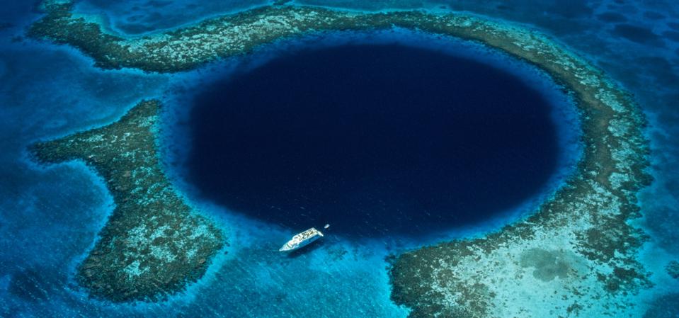
Sinkholes are natural depressions that form when rock dissolves or collapses, creating deep voids in the ground. While they are commonly found on land, they also exist in the ocean, often appearing as deep, circular pits in shallow coastal waters. These oceanic sinkholes typically originate from limestone caves that formed thousands of years ago, when sea levels were much lower. Over time, as rising waters flooded these caves, some collapsed, leaving behind the massive, submerged sinkholes we see today.
One of the largest and most famous of these is the Great Blue Hole, located off the coast of Belize. Measuring over 1,043 feet across and about 407 feet deep, this massive submarine sinkhole was known to local fishermen for generations. However, it wasn’t until the mid-20th century, as ocean exploration advanced, that it gained international attention.
As interest in the world’s oceans grew, so did the curiosity surrounding this geological anomaly.
Jacques Cousteau Introduced Millions To The Great Blue Hole, Thanks To His TV Show
By the late 1960s, ocean exploration was undergoing a transformation. Advancements in scuba technology, underwater photography and submersibles were making the deep sea more accessible than ever, while a surge in public fascination — driven by television and scientific curiosity — was pushing marine research into the mainstream.
At the forefront of this movement was Jacques Cousteau, a former French naval officer turned oceanographer, filmmaker and conservationist. Having already brought global attention to remote reefs, ancient shipwrecks and ecologically vital marine habitats, Cousteau had become a household name, blending scientific discovery with visual storytelling in ways no one had done before.
In 1971, Jacques Cousteau and his crew aboard the research vessel Calypso arrived in Belize to explore the Great Blue Hole — a massive, perfectly circular submarine sinkhole located in the Lighthouse Reef Atoll. This expedition was part of their renowned television series, The Undersea World of Jacques Cousteau.
Though geologists already understood its karstic origins to some degree, Cousteau’s approach to exploration was different. He was there to show it to the world. He was so enthralled, in fact, that he subsequently ranked it among his top ten scuba diving sites in the world.
Cousteau’s expedition provided the first widely publicized visual evidence that the Great Blue Hole had once been a dry limestone cave — formed during the last Ice Age, when sea levels were lower. His team’s footage of submerged stalactites supported existing geological theories, showing that the cave had collapsed and flooded as the oceans rose.
Nearly 50 Years Later, It Took Another TV Show To 3D Map The Hole
In the years that followed, the Great Blue Hole became a popular dive site, attracting marine researchers, geologists and adventurers eager to explore its mysteries. While its striking vertical walls and massive submerged stalactites remained a major draw, divers also began documenting the varied marine life that inhabits the sinkhole, including Caribbean reef sharks, giant groupers and other deep-sea species that navigate its depths.
However, a true, detailed mapping of the Great Blue Hole wouldn’t happen until nearly five decades later, when advancements in sonar technology and submersibles allowed for a complete digital reconstruction of the sinkhole’s interior.
It wasn’t until 2018 that Aquatica Submarines, in collaboration with Fabien Cousteau, Richard Branson and sub pilot Erika Bergman, used advanced sonar technology to create the first complete 3D digital model of its interior.
The exploration encountered a thick hydrogen sulfide layer at 300 feet, blocking out oxygen and light, creating a dead zone where no marine life could survive. Below this, the water was completely anoxic, preserving everything that had fallen in — including plastic waste and dead conches, which had sunk to the bottom without decomposing due to the extreme conditions.
The mapping also revealed a calcium carbonate layer at 290 feet, evidence that a thriving coral reef had once existed here before being submerged by rising seas. Additionally, divers observed sandfalls cascading down the sinkhole’s walls, a process that suggests the Great Blue Hole is slowly filling in over time.
The expedition was broadcast live on Discovery Channel. But while the technology had changed, the mission remained the same: to explore, document and inspire a new generation to understand and protect the ocean’s wonders.
The Great Blue Hole Is Now A ‘Time Capsule’ For Earth’s Climate
While the 2018 expedition gave us the first complete map of the Great Blue Hole, scientists have since discovered that its greatest secret is what’s buried at the bottom.
A November 2020 study extracted a nearly 9-meter-long core of sediment from the Great Blue Hole’s floor, revealing a 1,885-year-long record of climate change in the Caribbean. Each layer of sediment acts like a page in a history book, showing how sea temperatures, storm activity and even human influence have changed over time.
The findings confirmed that sea temperatures have been rising for nearly 2,000 years, with long-term climate patterns like “El Niño” and the “Atlantic Multidecadal Oscillation” playing a major role. The sediment also shows that hurricane activity peaked between 900 and 1300 CE — during what’s known as the Medieval Warm Period — when storms became more intense and frequent, eroding coastlines and washing more material into the Blue Hole.
But the most surprising discovery was evidence of modern human impact. The study found a sudden change in carbon composition after 1900, linked to the Industrial Revolution and the rise of fossil fuel emissions — a phenomenon known as the Suess Effect. This means that even this remote underwater sinkhole, first explored for its natural beauty, is now a record of human-caused climate change.
Want to see where your own climate concerns fit in to this larger trend? Take the science-backed Climate Change Worry Scale now and find out how your perspective compares.

